Last Seen
NW quarter of Section 35, Township 12S, Range 21E, 6 PM
Lexington Township, Johnson County, Kansas
This cemetery was located high on the Kaw bluff, overlooking Captain's Creek and the Weaver Bottoms in Douglas County, just south of the point where Captain's Creek flows into the Kaw River.
Johnson County
In 1859, the US granted a patent to Matthew King and family, of Douglas County, KS, for this land, and more, on both sides of the Douglas/Johnson County line. King, Treasurer to the Shawnee Tribe, fell from his horse and was killded in 1872. Upon his death the land was deeded to King's wife and children. The remmaining Kings sold their land shortly thereafter, and moved to Indian Territory with their fellow Shawnee. It is believed that Matthew King and other family members are buried here.
Douglas County
According to Eudora area residents who grew up on or near this land, the cemetery was located close to the bluff at the highest point. As children, these folks remember riding their horses in this area and seeing the old Indian cemetery. They describe the cemetery as being small, surrounded by an old wire fence, and completely overgrown. It was common knowledge at the time that this was an old Indian cemetery.
Site Visitation
On visiting the site, we discovered an old road leading up the side of the bluff to the top, a mortarless stone bridge, a natural rock outcropping with 3 man-made stone walls to enclose the area, and evidence of an early 1900s dump site. The dump site contained pieces of crockery, enamelware, and glass, including fragments of a Cod Liver Oil bottle, dated to around 1880. Small shards of both white and gray chert were found in one of the run-off beds at the top of the bluff, dating to prehistoric times.
Maps
The earliest aerial map found is from the USDA, dated 1959. At that time the land was cultivated and there was no indication of a cemetery.
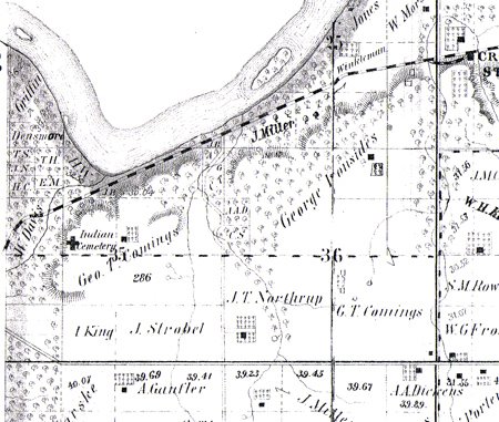
All atlas maps show the cemetery marked as Indian Cemetery. The 1886 atlas shows a Kaw ferry crossing close to this site, and there are indications that this may have been a ferry site as early as the 1850s, though it is apparent the ferry did not operate all of this time.
1874 Atlas, Johnson County, KS, Lexington Township, pg. 94 ( Geo T Comings )
1886 Atlas, Johnson County, KS, Lexington Township ( F M Cory )
1902 Atlas, Johnson County, KS, Lexington Township, pg. 26 ( F M Cory )
1922 Atlas, Johnson County, KS, Lexington Township, pg. 36 ( F M Cory )
1874 Atlas
1886 Atlas


No comments:
Post a Comment