Tuesday, September 26, 2006

Preserving Cemeteries: USGS GNIS

This is the first of a series of blogs about preserving cemeteries in ways you might not think of!

I just can’t take this alphabet soup!


For those that just have to know what each and every letter stands for, it’s the United States Geological Survey (USGS) Geographic Names Information System.


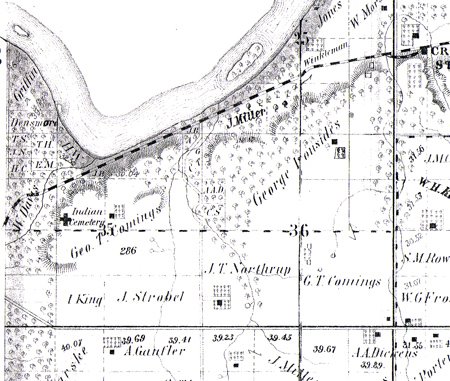
For those that don’t care about the fancy name, it’s a government database that tracks land-related features like rivers, mountains, populated places, churches, hospitals, and cemeteries, by a feature name, like river, mountain, populated place, etc. Check out the GNIS query page at http://geonames.usgs.gov/pls/gnispublic/

What does GNIS have to do with preservation?

Well, they aren’t out at the cemetery pulling weeds up and cleaning stones, that’s for sure! But what they do is preserve the location information – forever. As some of the old cemeteries grow over and disappear, their exact location can be found again, no guess-work needed. And that is a very good way to help preserve the cemetery.


How hard is it to add to the GNIS?

You have to supply a lot of information to the GNIS, and that can be a bit of work. But the good news is, if you include everything, it’s possible to add and update via email without using that nasty form on the website! Here's the grocery list:
  • State and County
  • Feature Name = Cemetery
  • Feature ID (if making a correction)
  • Proper Name (as registered with the County)
  • Latitude / longitude of center of cemetery
  • Principle Meridian, Range, Township, Section, ¼
  • References and documentation

Not as hard as you think

I use a Garmin hand-held GPS and stand in the center of the cemetery to take a reading. That gives me the exact lat/lon in decimal format. One call to the County Clerk or Land and Tax office should get you the proper name, the Range, Twp, Section, and if it's an open cemetery, the name of the Association responsible.

Use the Genweb and Interment.net sites as a reference, along with your county, and any book references or websites and you should be good to go!

Once it’s done, it's it’s there forever! It's a small investment for a lasting benefit.

Happy Geocoding!


Monday, September 25, 2006

Digital Cemetery Project: What's New

Saint Joseph Catholic Cemetery

Well, we’re definitely making headway with Saint Joseph Catholic Cemetery. Volunteer Carol Rollins sent me about 1600 of the near 2900 transcriptions. There were a number of stones that were difficult or illegible and I visited each one at the cemetery this weekend and gained a bit more of some of the inscriptions that are now so hard to make out.

After spending a good portion of Saturday trying to figure out what stones were in what Section/block./lot of the cemetery, we gave up. It just does not seem possible to make this determination looking at the cemetery and pacing off the graves. So in this transcription, while all of the Gardens and Gardens II additions will be marked to their blocks on the map, the front will only have the major section and a row number. This is best I can do without a lot of time-consuming help from the cemetery management.

I am hoping to have Saint Joseph Catholic Cemetery published sometime later this week!

De Soto Cemetery

We are also already making good progress on De Soto Cemetery. This may end up being our best transcription yet, thanks to Kathy Ross at De Soto Cemetery. She is working hard to verify each record, and visiting the cemetery to unbury some of the stones that have sunken or washed over with mud and sod.

Go Kathy Go!!

Saturday, September 23, 2006

King Indian Cemetery Missing Without a Trace

Codename: (Matthew) King Cemetery

Last Seen

NW quarter of Section 35, Township 12S, Range 21E, 6 PM

Lexington Township, Johnson County, Kansas

This cemetery was located high on the Kaw bluff, overlooking Captain's Creek and the Weaver Bottoms in Douglas County, just south of the point where Captain's Creek flows into the Kaw River.

Johnson County

In 1859, the US granted a patent to Matthew King and family, of Douglas County, KS, for this land, and more, on both sides of the Douglas/Johnson County line. King, Treasurer to the Shawnee Tribe, fell from his horse and was killded in 1872. Upon his death the land was deeded to King's wife and children. The remmaining Kings sold their land shortly thereafter, and moved to Indian Territory with their fellow Shawnee. It is believed that Matthew King and other family members are buried here.

Douglas County

According to Eudora area residents who grew up on or near this land, the cemetery was located close to the bluff at the highest point. As children, these folks remember riding their horses in this area and seeing the old Indian cemetery. They describe the cemetery as being small, surrounded by an old wire fence, and completely overgrown. It was common knowledge at the time that this was an old Indian cemetery.

Site Visitation

On visiting the site, we discovered an old road leading up the side of the bluff to the top, a mortarless stone bridge, a natural rock outcropping with 3 man-made stone walls to enclose the area, and evidence of an early 1900s dump site. The dump site contained pieces of crockery, enamelware, and glass, including fragments of a Cod Liver Oil bottle, dated to around 1880. Small shards of both white and gray chert were found in one of the run-off beds at the top of the bluff, dating to prehistoric times.

Maps

The earliest aerial map found is from the USDA, dated 1959. At that time the land was cultivated and there was no indication of a cemetery.
All atlas maps show the cemetery marked as Indian Cemetery. The 1886 atlas shows a Kaw ferry crossing close to this site, and there are indications that this may have been a ferry site as early as the 1850s, though it is apparent the ferry did not operate all of this time.

1874 Atlas, Johnson County, KS, Lexington Township, pg. 94 ( Geo T Comings )
1886 Atlas, Johnson County, KS, Lexington Township ( F M Cory )
1902 Atlas, Johnson County, KS, Lexington Township, pg. 26 ( F M Cory )
1922 Atlas, Johnson County, KS, Lexington Township, pg. 36 ( F M Cory )

1874 Atlas


1886 Atlas


Friday, September 22, 2006

Character Markers?

I have a couple of cute character markers I thought might be fun to share. I hope you enjoy them.

Smurf at Pleasant View Cemetery
Smurf
Pleasant View Cemetery
Shawnee, Johnson County, Kansas

Raggedy Ann at Edgerton Cemetery

Raggedy Ann
Edgerton Cemetery
Edgerton, Johnson County, Kansas

Bear at De Soto Cemetery
Bear
De Soto Cemetery
De Soto, Johnson County, Kansas


Bear
De Soto Cemetery
De Soto, Johnson County, Kansas

Thursday, September 21, 2006

Photographing for the Digital Cemetery Project

The Camera

In order to successfully digitize a cemetery you will need a decent digital camera. The camera should be capable of taking print-quality photos at color 2048 X 1024 at 300dpi. The last number (300 dpi) is the most important part. At 300 dpi, the camera sees more than the human eye and often unreadable stones become more legible. These settings produce clear, easy to read photos that can be zoomed to a high magnification level as well as enable researchers’ access to printable photos. Each photo will be approximately ½ MB in size, so be sure to have a couple of large memory cards for your camera.

Before You Begin

The first step, before beginning to photograph, is to scope out the cemetery and get a feel for the physical layout, and determine a plan to proceed. It is important to begin each physical section from a known location (such as the NE corner) and to photograph row by row so that the path can be retraced later to check the stones, and to assist researchers in physically locating the stone at the cemetery.

Although it is not necessary to begin this way, I find it helpful to walk the row first to pull weeds away and sweep or dig out stones, and see what obstacles lay ahead. For me, if I can get everything ready, then the photographing itself goes very fast, but when I have to stop and clean a stone, my camera shuts off and I lose momentum and it seems to take a lot longer.

Photographing

In the cemeteries with older stones, there are usually family groupings or stones that are related. In these cases I like to take a group photo to be attached to each individual, to preserve that relationship.

In the more recent burials there are usually some couples headstones with a military plaque either attached to the back of the monument, or used as a footstone. It is best to get those with the headstone, and that is always my goal, but unfortunately is the thing I miss the most often. When I miss it, I get it in the next row, and I also retake the front of the stone to help me locate the previous entry when transcribing.

I often take photos of old stones from all sides, or at least all sides that appear to be inscribed, followed by close-ups of the inscriptions. This helps to provide clarity both when transcribing and to the researcher.

I try to take angle shots of stones that are difficult to read due to their condition or their coloration. Sometimes by getting almost a side shot the inscription will pop out. Sometimes it takes multiple angles to uncover the entire inscription. Another trick to help pop out the inscription is to use a mirror to reflect sunlight at the inscription and cast shadows in a different way than is natural.

Conventions

In order to help the transcription process, and to help track where I am in the cemetery, at the end of each row I take a photo of my index finger. That way, when transcribing I know when to increment the row number, and if I have to go back to the cemetery and look at one of the stones, I know where to find it.

Similarly, at the end of each physical section, I take a photograph of my hand splayed, often followed by some photos of the section from the location where I ended.

Wednesday, September 20, 2006

The World of the Cemetery Sexton

In broad strokes, the role of a sexton is to take charge of, care for, and supervise the cemetery, under the direction of the Cemetery Board or other governing party. What does that really mean?

Opening and Closing Graves

One of the main functions of a sexton is to open and close graves for interments. In order to do that, the sexton must know where the plots are physically located in the cemetery, the dimensions of the plots, and which graves are filled, and it is the sexton’s responsibility not to disturb prior interments when opening graves. It would not be a good thing for the backhoe to hit another casket. In some cases this means that the sexton must use a Sexton’s Key to probe the ground and make certain the neighboring graves will not be disturbed.

Selling Plots

Another major function of a cemetery sexton is to be able to show prospective buyers available lots. That means that the sexton must not only keep up with what plots are filled, but also what lots are sold. The sale of a cemetery plot is pretty much like the sale of any real estate.

Placing Headstones

Similarly, once a headstone is shipped to the cemetery, it is the sexton’s responsibility to know where the monument is to be installed and direct the installation. In many cemeteries, it is also the sexton’s responsibility to notify the installers when the stone arrives.

Grounds Maintenance

The cemetery sexton is also responsible for the grounds, turf, and landscaping maintenance. This not only includes mowing, but also the upkeep of trees and plantings, the cemetery fence (if there is one), signage, and any memorial areas in the cemetery.

Rules and Regs

One of the least favorite jobs of a sexton is enforcing the cemetery rules and regulations. This includes when people can visit, conduct in the cemetery, and litter. Similarly most modern cemeteries have rules about what can be installed at a grave, and what can be placed at a grave. Some cemeteries do not allow planting at graves, holiday decorations, lighting, or other memorabilia, while other will allow some or all of these things. Many cemeteries have rules about live and even artificial flowers and post signage stating flowers will be removed on a certain date. This helps to keep the cemetery clean and fresh of pots of death flowers throughout the harsh winter.

It’s all about the Map

Modern cemeteries are typically platted out and every square inch is accounted for. The cemetery may be comprised of different lot layouts in different sections of the cemetery. There may be differing sizes of graves and usually some smaller crematory plots. A map is created and each grave is identified by some naming or numbering scheme, usually identifying sections, blocks, lots, and plots, and it is the job of the sexton to maintain this map. This map is essential in the ability to do their job.

Not a Mason

It may seem that the sexton has an obligation with regard to the maintenance of markers and monuments; however this is not the case. The monuments are owned by the purchaser and installed on private property (the purchased lot) and it is really the responsibility of the family to perform any cleaning or repair. However, some cemeteries do step up and try to repair and curate old broken stones which have long been forgotten. This is purely a voluntary action on their part, and if they do it, it’s because they love their cemetery.

Not a Genealogist

While many people contact cemetery sextons to find out genealogical information on past interments, answering these types of questions, and doing genealogy is NOT their responsibility, and if they choose to provide this information, it is purely of their own free will.

Your Faithful Caretaker

Always remember – it is not the job of a sexton to know what is inscribed on the stone, or the relationship of any individual to any other individual, or to fix a broken stone – but rather it is their job to keep up the cemetery and to know who is buried where, what lots are sold, and what lots are available. They have to deal with the finality of death, eternal resting places of loved ones of the living, and be sensitive to the emotional state of the public, sometimes during their time of great loss.


It’s not just a job.

Monday, September 18, 2006

Transcribing for the Digital Cemetery Project

How Do I Begin?

The easiest way to transcribe the gravestones from the digital photographs is to arrange your screen so that you can see both the photo and the Excel template at the same time. To do this I open the template, make it the width of the screen, and then size it down to the lower 1/3 of the screen. Then open the photo viewer and size it to fit in the space above the template. With just a click you can zoom in on the photo for better clarity and use the viewer navigation to move through the photos.

Screen Layout Example


There will likely be a number of photos that are unreadable, due to poor photographs, stones that don’t photograph well, or stones that are just in very bad shape. Enter the information you can read, if any, along with the photograph file name, and highlight the record using a fill color. I will take these out to the cemetery to try to gain more clarity before finalizing the transcription for publication.

The Template

The Excel template is used to enter all the transcriptions, usually in the format of one tab per section of the cemetery. When the transcriptions are completed and ready for publication, the template is uploaded into the database and the records immediately appear on my cemetery work site. From there, with a little effort, I can publish to Genweb, Interment.net, and book formats, as well as generate a static Surname index for sites that do not support dynamic content (like Genweb or books).

Below is a list of the column headings in the transcription template. Each entry is followed by a brief explanation of the field and what should be entered there. Enter only the information that appears on a stone. Do not fill in information that is not given (ie do not calculate ages).


cid : Cemetery ID from the database – hidden field, please ignore
id : Transcription ID generated from the database – hidden field, please ignore
Surname : Surname only
Givenname : Includes first, middle, maiden name, titles (Dr, Sr, III)
BD : Two-digit birth day (use leading zero) *
BM : Two-digit birth month (use leading zero) *
BY : Four-digit birth year
BPlace : Birth Place can include country, county, state, city
DD : Two-digit death day (use leading zero) *
DM : Two-digit death month (use leading zero) *
DY : Four-digit death year
DPlace : Death Place can include country, county, state, city
AY : Age years (no leading zero)
AM : Age months (no leading zero)
AD : Age days (no leading zero)
MD : Two-digit marriage day (use leading zero) *
MM : Two-digit marriage month (use leading zero) *
MY : Four-digit marriage year
Inscription : Inscription personal items only, such as military service, Father, Mother, Husband, Wife, Son of …, Parents of …, Infant, Erected by, etc. Also include fraternal and other organization symbols, such as Woodmen of the World, Mason, Odd Fellows, etc. Do not include epitaphs or Bible verses or poems.
Notes : If more than one person on a stone, enter s/w (same stone with) followed by the full names of the other people on this stone. If more than 3 people, name the stone (such as Young-Lewis stone) and enter this on all related records. Other possible entries here include notations about the condition of the stone, indication if the source is a metal funeral home marker, indication of veteran or other medallions.
Photo : The file name of the photo in uppercase, ie DSCN1203.JPG. If several photos exist for a person or transcription, enter them all in this field separated only by a comma (no spaces). There are many group photos and Family stones that should be appended to each transcription that is pictured in the photo.
Vet : 0 (default), or 1 to indicate transcription of a Veteran
Row : Row in the cemetery based on order photos taken. Photos of a single finger indicate the end of a row.
Section : Name of the section, based on sexton’s map or predetermined naming convention (usually same name as tab)
Block : From sexton’s map, where exists.
Lot : From sexton’s map, where exists.
PhotoDir : Directory and subdirectory (where exists) of photo file used by the database to display the photo links.

* Template is set up to automatically add the leading zero to the fields where this is required. Please do not reformat the template.

Other Template Notes

- DO NOT USE THE AMPERSAND (&)! This can cause publishing to break in some formats. Please spell out the word ‘and’ in place of using the ampersand.

- DO NOT USE PERIODS – just leave them out! DO use a space to separate initials.

- HIGHLIGHT the bad or questionable entries.

- SUBSTITUTE a question mark (?) for a letter or number that is not legible.

- WATCH the GIVENNAME – Excel will often autofill as you type, taking names from the previous entries in that column. If you are typing the name John, Excel might fill in John S from a previous entry. Sometimes you have to DELETE things you didn’t type from the Givenname.

About the Photos

- A photo of a single finger signals the end of a row. Do not index the index finger, just increment the row number in the transcription.

- A photo of a hand signifies the end of a section. This is often followed by photos of the preceding section from the finish point, and sometimes photos from the starting point of the next section. Do not index the hand or area photos.

- Add the transcriptions in order within a tab. If there are several batches within a folder, please do not skip around. The photos are taken in order beginning from a known location.

- There may be group shots to be added to all individuals

- There will be Individual photos of family stones to be added to all individuals. You may encounter one or two stones with no surname right before the family stone.

- There may be multiple photos of the same side of a stone, usually because they don’t look good. Just choose the best and index – no need to index 3 of the same photo.

- Some people have multiple stones or have information on the reverse side of the monument. Sometimes we miss that on the row when photographing and have to get them on the next row, or later. Please watch out for duplicate names and do not make a second entry for the same person. Just add the additional information to the first transcription, and chain on the photo file name

Digital Cemetery Project: What's New

Well, it has been another busy and successful weekend photographing gravestones. This weekend Bruce and I managed to photograph all the stones at the De Soto cemetery! This adds yet another photographed cemetery to the list waiting to be transcribed. I sure do wish the transcription part went as fast as the photography!

As of today, the following cemeteries are photographed and ready to transcribe:

    • De Soto
    • Edgerton
    • Lenexa
    • Spring Hill
    • Union
Saint Joseph almost ready for prime time!

Saint Joseph Catholic Cemetery is officially transcribed! I want to extend my sincere and heart felt thanks to Carol Rollins, once again, for her help with transcribing the front part of the cemetery. With out her help it would probably be next year before it was completed. When it is ready to publish, Saint Joseph will be the biggest cemetery completed in the Digital Cemetery Project. Ah, but the just keep getting larger – that’s what I get for putting the largest ones last!

So, now I need to take the St Joseph transcription back to the cemetery and work on interpreting the stones that were unreadable in the photos, and try to index the front half of the cemetery to the sexton’s map. It will still be a while before St Joseph is published, but we’re definitely getting closer by the day!

And now it is time to return to the daily grind of earning a living to support this darned hobby of mine!

Friday, September 15, 2006

It’s My Party and I’ll Blog If I Want To

Welcome to the Digital Cemetery blog where you can read about all aspects of cemeteries, cemetery research, and the current happenings in the Digital Cemetery Project. Whether you are a cemeterian, sexton, researcher, or just want to know that the heck these people like to talk about, this is the place for you!

What’s the point

The goal of the Digital Cemetery Project is to collect and preserve cemetery information for historical reference by creating electronic and photographic records, and making them freely available to the public. This project is beginning by digitizing the Johnson County, Kansas, cemeteries. Why Johnson County, you ask? Because that’s where I live and there’s no place like home, Dorothy!

Who cares about this stuff?

You are probably thinking that there are, at most, a handful of people with Johnson County roots who are out there researching their own genealogy and might get a kick out of the Digital Cemetery. Ding, ding, ding - you are correct! As those of us geneaologists know well, hardly anyone hires genealogists these days; we have now become a self-service society. Now, at best, researchers are asked to do an occaisional mind-numbing look-up task that can't be gotten to any other way. But with gravestones, many people want the photo to use as proof to join a hereditary society like the DAR and SUV.

So, what’s the payoff?

Is it really worth all this work just for a few genealogy seekers? You bet it is! As it turns out, the DIY genies are only a small percentage of the audience! The majority of people that dig through the cemeteries and transcription sites are not the handful looking for great great Grandmama Addams, but are the many looking for their Aunt Effie, Grandpa Jones, or their own parents or siblings! And I, personally, I’ve found no better payoff than receiving the occasional email of thanks for bringing a person’s loved one home to them.

You’ve GOT to be Kidding me!

Once upon a time families lived together in the same area, sometimes even the same homestead, for generations. But today people are mobile and more likely than not, don’t live near where their loved ones are interred. The living family may not be able to go to the cemetery, but now their loved ones can be brought home to them in transcriptions, photos, and cemetery histories, through the Digital Cemetery. And if they want to plan a pilgramage to visit their graves, they can find maps and information to help them too.

Look out!

Believe it or not, there are others out there as wacko as I am that just love cemeteries, and we're out of the closet! Some are into the symbolism, some are into the inscriptions, some are into the stone carvers, and some people just into history! You can find many such experts (and avid enthusiasts like myself) in the Association for Gravestone Studies membership.

SSDD (Same Stuff Different Day)

There is plenty to dig in to and blog about when it comes to cemeteries! Stay tuned for information about the Digital Cemetery Project. I hope you’ll join me and add your questions, thoughts, and blogs about cemeteries too.