Tuesday, September 26, 2006

Preserving Cemeteries: USGS GNIS

This is the first of a series of blogs about preserving cemeteries in ways you might not think of!

I just can’t take this alphabet soup!


For those that just have to know what each and every letter stands for, it’s the United States Geological Survey (USGS) Geographic Names Information System.


For those that don’t care about the fancy name, it’s a government database that tracks land-related features like rivers, mountains, populated places, churches, hospitals, and cemeteries, by a feature name, like river, mountain, populated place, etc. Check out the GNIS query page at http://geonames.usgs.gov/pls/gnispublic/

What does GNIS have to do with preservation?

Well, they aren’t out at the cemetery pulling weeds up and cleaning stones, that’s for sure! But what they do is preserve the location information – forever. As some of the old cemeteries grow over and disappear, their exact location can be found again, no guess-work needed. And that is a very good way to help preserve the cemetery.


How hard is it to add to the GNIS?

You have to supply a lot of information to the GNIS, and that can be a bit of work. But the good news is, if you include everything, it’s possible to add and update via email without using that nasty form on the website! Here's the grocery list:
  • State and County
  • Feature Name = Cemetery
  • Feature ID (if making a correction)
  • Proper Name (as registered with the County)
  • Latitude / longitude of center of cemetery
  • Principle Meridian, Range, Township, Section, ¼
  • References and documentation

Not as hard as you think

I use a Garmin hand-held GPS and stand in the center of the cemetery to take a reading. That gives me the exact lat/lon in decimal format. One call to the County Clerk or Land and Tax office should get you the proper name, the Range, Twp, Section, and if it's an open cemetery, the name of the Association responsible.

Use the Genweb and Interment.net sites as a reference, along with your county, and any book references or websites and you should be good to go!

Once it’s done, it's it’s there forever! It's a small investment for a lasting benefit.

Happy Geocoding!


Monday, September 25, 2006

Digital Cemetery Project: What's New

Saint Joseph Catholic Cemetery

Well, we’re definitely making headway with Saint Joseph Catholic Cemetery. Volunteer Carol Rollins sent me about 1600 of the near 2900 transcriptions. There were a number of stones that were difficult or illegible and I visited each one at the cemetery this weekend and gained a bit more of some of the inscriptions that are now so hard to make out.

After spending a good portion of Saturday trying to figure out what stones were in what Section/block./lot of the cemetery, we gave up. It just does not seem possible to make this determination looking at the cemetery and pacing off the graves. So in this transcription, while all of the Gardens and Gardens II additions will be marked to their blocks on the map, the front will only have the major section and a row number. This is best I can do without a lot of time-consuming help from the cemetery management.

I am hoping to have Saint Joseph Catholic Cemetery published sometime later this week!

De Soto Cemetery

We are also already making good progress on De Soto Cemetery. This may end up being our best transcription yet, thanks to Kathy Ross at De Soto Cemetery. She is working hard to verify each record, and visiting the cemetery to unbury some of the stones that have sunken or washed over with mud and sod.

Go Kathy Go!!

Saturday, September 23, 2006

King Indian Cemetery Missing Without a Trace

Codename: (Matthew) King Cemetery

Last Seen

NW quarter of Section 35, Township 12S, Range 21E, 6 PM

Lexington Township, Johnson County, Kansas

This cemetery was located high on the Kaw bluff, overlooking Captain's Creek and the Weaver Bottoms in Douglas County, just south of the point where Captain's Creek flows into the Kaw River.

Johnson County

In 1859, the US granted a patent to Matthew King and family, of Douglas County, KS, for this land, and more, on both sides of the Douglas/Johnson County line. King, Treasurer to the Shawnee Tribe, fell from his horse and was killded in 1872. Upon his death the land was deeded to King's wife and children. The remmaining Kings sold their land shortly thereafter, and moved to Indian Territory with their fellow Shawnee. It is believed that Matthew King and other family members are buried here.

Douglas County

According to Eudora area residents who grew up on or near this land, the cemetery was located close to the bluff at the highest point. As children, these folks remember riding their horses in this area and seeing the old Indian cemetery. They describe the cemetery as being small, surrounded by an old wire fence, and completely overgrown. It was common knowledge at the time that this was an old Indian cemetery.

Site Visitation

On visiting the site, we discovered an old road leading up the side of the bluff to the top, a mortarless stone bridge, a natural rock outcropping with 3 man-made stone walls to enclose the area, and evidence of an early 1900s dump site. The dump site contained pieces of crockery, enamelware, and glass, including fragments of a Cod Liver Oil bottle, dated to around 1880. Small shards of both white and gray chert were found in one of the run-off beds at the top of the bluff, dating to prehistoric times.

Maps

The earliest aerial map found is from the USDA, dated 1959. At that time the land was cultivated and there was no indication of a cemetery.
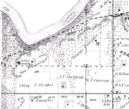
All atlas maps show the cemetery marked as Indian Cemetery. The 1886 atlas shows a Kaw ferry crossing close to this site, and there are indications that this may have been a ferry site as early as the 1850s, though it is apparent the ferry did not operate all of this time.

1874 Atlas, Johnson County, KS, Lexington Township, pg. 94 ( Geo T Comings )
1886 Atlas, Johnson County, KS, Lexington Township ( F M Cory )
1902 Atlas, Johnson County, KS, Lexington Township, pg. 26 ( F M Cory )
1922 Atlas, Johnson County, KS, Lexington Township, pg. 36 ( F M Cory )

1874 Atlas


1886 Atlas